Run No.: 2721 Date: Sunday 2 August 2026 Time: 1pm – 13.00h Fee: 5€ (+2€ for the driver if you get a lift), it covers all the drinks and the snacks.
If you need a lift to get to the run, PLEASE let us know beforehand so we can arrange it, seats are limited sometimes.
Location: Recinto Ferial de Casa de Campo (Casa de Campo) GPS: [40°24’48.3″N 3°44’07.5″W] or [40.413419, -3.735413]
Directions by public transport: More info?
Take Line 10 (Puerta del Sur) and get off at Lago. Exit the station and turn right onto Rda. del Lago. Take the left fork onto C. del Arroz. When you get to the next intersection, turn left into C. del Ferial. Turn right after that into Trav. del Vivero and the CP should be 100m in front of you
Driving directions (from Cuzco):
Take the M-30. Follow signs towards A-5 Badajoz and merge onto the A-5. Take the Exit towards C. de Dante and at the roundabout, take the 3rd exit to stay on C. de Dante. The the next roundabout, take the 1st exit towards M-30/Avda. de Portugal and take a slight right onto the Avda. Portugal ramp. At the next roundabout, take the 2nd exit onto Av Principal and at the next roundabout the 1st exit onto C Principal de Provincias. After 400m turn right into the CP.
Hares: Smile Like You Like It & Something In My Mouth
– There are cars available to drop your bag while you run. – Down-downs will be from your own drinking vessel (or can). Feel free to bring your Hash mug or other drinking vessel.
It’s a PICNIC R*N, so if you want to eat after the r*n, bring your own food. It will be hot, bring water, sunscreen and a hat for the run!
ON ON!
*IMPORTANT NOTICE* English
Hashing is NOT a guided activity, nor is it led by professionals. If you take part in a Hash run or walk you do so of your own free will, voluntarily and fully aware that it is not guided. The Madrid Hash House Harriers merely schedules the activity and publishes details of the same.
We would remind you that running, whether that be in the mountains, outdoors in general or in urban areas, entails a number of inherent risks depending on the terrain. The mountain environment particularly is uncontrollable and can at times be hostile. By taking part in this activity you accept those risks.
Each participant must be aware of their own physical condition and must decide whether or not to take part based on the details of the activity provided. Participants are responsible for their own safety and should not take part unless they are sure that they will be able to perform the activity without placing themselves or others at risk. Each participant is responsible for wearing/carrying with them any equipment that they may need to take part in the activity safely (including water, a cap and sun-cream in hot weather, clothing appropriate to the conditions, be that hot, cold or wet). They must also heed any instructions given to them by the organisers. All participants understand that they bear their own responsibility should they fail to heed or comply with the above obligations.
*MUY IMPORTANTE* Español
Esta actividad NO es guiada, ni dirigida o tutelada por profesionales. Los participantes en un Hash lo hacen de forma libre, voluntaria y consciente de ello. El Madrid Hash House Harriers se limita a organizar la convocatoria y publicar la misma.
Recordamos que la actividad de correr, sea en montaña, en campo o en ciudad, tiene sus riesgos. Cada terreno tiene sus riesgos propios, y la montaña en particular es absolutamente incontrolable y puede resultar en ocasiones hostil. Al participar en esta actividad se asumen estos riesgos.
Es responsabilidad y obligación de cada uno el conocer su propia condición física para poder realizar la actividad de forma segura para uno mismo y para los demás participantes. Cada uno es responsable de llevar el equipo necesario para el desarrollo de la actividad (que incluye agua, una gorra y crema solar en caso de calor, vestimenta adecuada en base al tiempo). También deben atender y acatar en todo momento las indicaciones de los responsables de la actividad, comprendiendo su responsabilidad en el caso de no hacerlo o de hacer caso omiso de éstas obligaciones.
Run No.: 2720 Date: Sunday 26 July 2026 Time: 1pm – 13:00h Fee: 5€ (+2€ for the driver if you get a lift), it covers all the drinks and the snacks.
If you need a lift to get to the run, PLEASE let us know beforehand so we can arrange it, seats are limited sometimes.
Location: Calle del Arroyo del Calderillo (Los Berrocales del Jarama) GPS: [40°28’40.4″N 3°30’59.0″W] or [40.477889, -3.516389]
Public transport is a bit challenging this time around, perhaps offering sexual favors to your favourite driver is a more suitable option.
Driving directions (from Cuzco):
– Alberto de Alcocer EAST to M30 anticlockwise.
– Use the right 2 lanes to take exit 5AB onto A-2 towards Zaragoza/Aeropuerto
– Take exit 17A for M-115 towards M-50/M-45/R-2/Ajalvir (At the ‘Y’ stay LEFT)
– At roundabout, go STRAIGHT to stay on M-115
– At roundabout, turn LEFT to LOS BERROCALES
– At the roundabout, GO STRAIGHT.
– At the Roundabout, turn LEFT into Paseo Quintana
– After 50m, turn right to C/ del Arroyo del Calderillo
– C.P. will be on the left.
– There are cars available to drop your bag while you run. – Down-downs will be from your own drinking vessel (or can). Feel free to bring your Hash mug or other drinking vessel.
It’s a PICNIC R*N, so if you want to eat after the r*n, bring your own food. It will be hot, bring water, sunscreen and a hat for the run!
ON ON!
*IMPORTANT NOTICE* English
Hashing is NOT a guided activity, nor is it led by professionals. If you take part in a Hash run or walk you do so of your own free will, voluntarily and fully aware that it is not guided. The Madrid Hash House Harriers merely schedules the activity and publishes details of the same.
We would remind you that running, whether that be in the mountains, outdoors in general or in urban areas, entails a number of inherent risks depending on the terrain. The mountain environment particularly is uncontrollable and can at times be hostile. By taking part in this activity you accept those risks.
Each participant must be aware of their own physical condition and must decide whether or not to take part based on the details of the activity provided. Participants are responsible for their own safety and should not take part unless they are sure that they will be able to perform the activity without placing themselves or others at risk. Each participant is responsible for wearing/carrying with them any equipment that they may need to take part in the activity safely (including water, a cap and sun-cream in hot weather, clothing appropriate to the conditions, be that hot, cold or wet). They must also heed any instructions given to them by the organisers. All participants understand that they bear their own responsibility should they fail to heed or comply with the above obligations.
*MUY IMPORTANTE* Español
Esta actividad NO es guiada, ni dirigida o tutelada por profesionales. Los participantes en un Hash lo hacen de forma libre, voluntaria y consciente de ello. El Madrid Hash House Harriers se limita a organizar la convocatoria y publicar la misma.
Recordamos que la actividad de correr, sea en montaña, en campo o en ciudad, tiene sus riesgos. Cada terreno tiene sus riesgos propios, y la montaña en particular es absolutamente incontrolable y puede resultar en ocasiones hostil. Al participar en esta actividad se asumen estos riesgos.
Es responsabilidad y obligación de cada uno el conocer su propia condición física para poder realizar la actividad de forma segura para uno mismo y para los demás participantes. Cada uno es responsable de llevar el equipo necesario para el desarrollo de la actividad (que incluye agua, una gorra y crema solar en caso de calor, vestimenta adecuada en base al tiempo). También deben atender y acatar en todo momento las indicaciones de los responsables de la actividad, comprendiendo su responsabilidad en el caso de no hacerlo o de hacer caso omiso de éstas obligaciones.
Run No.: 2719 Date: Sunday 19 July 2026 Time: 1pm – 13:00h Fee: 5€ (+2€ for the driver if you get a lift), it covers all the drinks and the snacks.
If you need a lift to get to the run, PLEASE let us know beforehand so we can arrange it, seats are limited sometimes.
Location: Valdemanco
GPS: [40°52’16.2″N 3°39’25.9″W] or [40.871181, -3.657190]
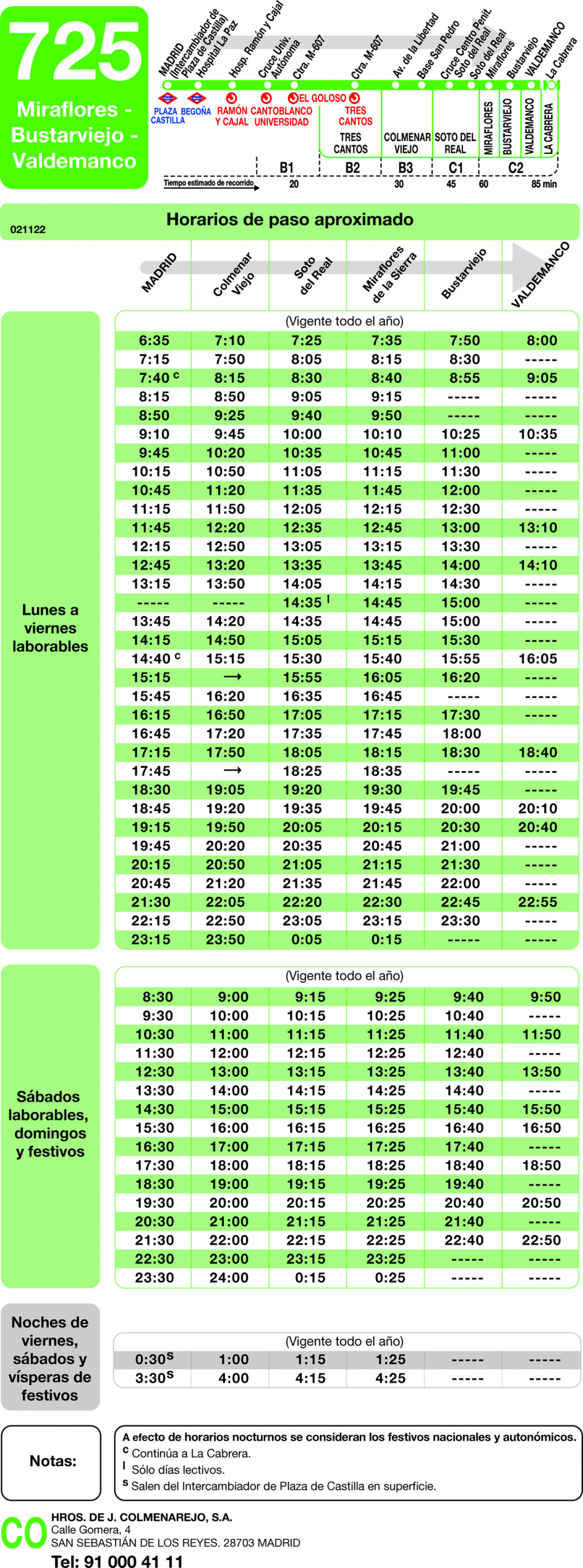
Take Bus 725 from Plaza de Castilla (darsena/platform 28, nivel -3, isla 2) at 10:30 (the bus to Valdemanco only runs every 2 hours) to Valdemanco. The bus should take 1h20 minutes. Exit at the Valdemanco-Av.Desvio Bus Stop. Walk along the M-610 and turn left into C. Arroyito, then 2nd right onto C. el Baile, 2nd left into C. de las Eras and 1st right into C. de las Malezas. Follow the road up the hill and the CP will be at the end of the road (next to the Tanatorio)
Driving directions (from Cuzco):
Go North on the A-1 and exit 57 toward La Cabrera/M-610/Valdemanco and turn left at the Stop street and go over the bridge. At the 1st roundabout, take the 4th exit onto the M-610 towards Valdemanco. When you reach Valdemanco, take the 1st right into C. de las Eras (be careful as the GPS tries to take you on a dirt road to the right before getting to Valdemanco – AVOID this and carry on driving into Valdemanco). Follow the road and turn right into C. de las Malezas. Follow the road up the hill until you get to the CP (next to the Tanatorio)
– There are cars available to drop your bag while you run. – Down-downs will be from your own drinking vessel (or can). Feel free to bring your Hash mug or other drinking vessel.
It’s a PICNIC R*N, so if you want to eat after the r*n, bring your own food. It will be hot, bring water, sunscreen and a hat for the run!
ON ON!
*IMPORTANT NOTICE* English
Hashing is NOT a guided activity, nor is it led by professionals. If you take part in a Hash run or walk you do so of your own free will, voluntarily and fully aware that it is not guided. The Madrid Hash House Harriers merely schedules the activity and publishes details of the same.
We would remind you that running, whether that be in the mountains, outdoors in general or in urban areas, entails a number of inherent risks depending on the terrain. The mountain environment particularly is uncontrollable and can at times be hostile. By taking part in this activity you accept those risks.
Each participant must be aware of their own physical condition and must decide whether or not to take part based on the details of the activity provided. Participants are responsible for their own safety and should not take part unless they are sure that they will be able to perform the activity without placing themselves or others at risk. Each participant is responsible for wearing/carrying with them any equipment that they may need to take part in the activity safely (including water, a cap and sun-cream in hot weather, clothing appropriate to the conditions, be that hot, cold or wet). They must also heed any instructions given to them by the organisers. All participants understand that they bear their own responsibility should they fail to heed or comply with the above obligations.
*MUY IMPORTANTE* Español
Esta actividad NO es guiada, ni dirigida o tutelada por profesionales. Los participantes en un Hash lo hacen de forma libre, voluntaria y consciente de ello. El Madrid Hash House Harriers se limita a organizar la convocatoria y publicar la misma.
Recordamos que la actividad de correr, sea en montaña, en campo o en ciudad, tiene sus riesgos. Cada terreno tiene sus riesgos propios, y la montaña en particular es absolutamente incontrolable y puede resultar en ocasiones hostil. Al participar en esta actividad se asumen estos riesgos.
Es responsabilidad y obligación de cada uno el conocer su propia condición física para poder realizar la actividad de forma segura para uno mismo y para los demás participantes. Cada uno es responsable de llevar el equipo necesario para el desarrollo de la actividad (que incluye agua, una gorra y crema solar en caso de calor, vestimenta adecuada en base al tiempo). También deben atender y acatar en todo momento las indicaciones de los responsables de la actividad, comprendiendo su responsabilidad en el caso de no hacerlo o de hacer caso omiso de éstas obligaciones.
Run No.: 2717 Date: Sunday 5 July 2026 Time: 1pm – 13:00h Fee: 5€ (+2€ for the driver if you get a lift), it covers all the drinks and the snacks.
Location: Very Grimm’s Palace, Metro Valdezarza. Calle Valle de Cardos, 34 GPS: [40.466986, -3.712701] or [40°28’01.2″N 3°42’45.7″W]
Directions by public transport: More info?
Metro line 7 (orange), stop “Valdezarza”, follow flour/chalk or use GPS to Calle Valle de Cardos, 34.
Driving directions (from Cuzco):
Go straight on Sor Angela De La Cruz street (& tunnel) until the roundabout AFTER the big park.
On that roundabout turn around (4th exit) & take the exit to “Serafín Rodríguez” street on your right.
First street to your left is Valle de Cardos, find a parking space.
– Down-downs will be from your own drinking vessel (or can). Feel free to bring your Hash mug or other drinking vessel.
There will be food to share after the circle at Grimm’s place. It is a bring and share, so please bring a savoury dish or dessert. Very Grimm will make at least 1 curry.
ON ON!
*IMPORTANT NOTICE* English
Hashing is NOT a guided activity, nor is it led by professionals. If you take part in a Hash run or walk you do so of your own free will, voluntarily and fully aware that it is not guided. The Madrid Hash House Harriers merely schedules the activity and publishes details of the same.
We would remind you that running, whether that be in the mountains, outdoors in general or in urban areas, entails a number of inherent risks depending on the terrain. The mountain environment particularly is uncontrollable and can at times be hostile. By taking part in this activity you accept those risks.
Each participant must be aware of their own physical condition and must decide whether or not to take part based on the details of the activity provided. Participants are responsible for their own safety and should not take part unless they are sure that they will be able to perform the activity without placing themselves or others at risk. Each participant is responsible for wearing/carrying with them any equipment that they may need to take part in the activity safely (including water, a cap and sun-cream in hot weather, clothing appropriate to the conditions, be that hot, cold or wet). They must also heed any instructions given to them by the organisers. All participants understand that they bear their own responsibility should they fail to heed or comply with the above obligations.
*MUY IMPORTANTE* Español
Esta actividad NO es guiada, ni dirigida o tutelada por profesionales. Los participantes en un Hash lo hacen de forma libre, voluntaria y consciente de ello. El Madrid Hash House Harriers se limita a organizar la convocatoria y publicar la misma.
Recordamos que la actividad de correr, sea en montaña, en campo o en ciudad, tiene sus riesgos. Cada terreno tiene sus riesgos propios, y la montaña en particular es absolutamente incontrolable y puede resultar en ocasiones hostil. Al participar en esta actividad se asumen estos riesgos.
Es responsabilidad y obligación de cada uno el conocer su propia condición física para poder realizar la actividad de forma segura para uno mismo y para los demás participantes. Cada uno es responsable de llevar el equipo necesario para el desarrollo de la actividad (que incluye agua, una gorra y crema solar en caso de calor, vestimenta adecuada en base al tiempo). También deben atender y acatar en todo momento las indicaciones de los responsables de la actividad, comprendiendo su responsabilidad en el caso de no hacerlo o de hacer caso omiso de éstas obligaciones.
Run No.: 2716 Date: Sunday 28 June 2026 Time: 1pm – 13:00h Fee: 5€ (+2€ for the driver if you get a lift), it covers all the drinks and the snacks.
If you need a lift to get to the run, PLEASE let us know beforehand so we can arrange it, seats are limited sometimes.
Location: Las Matas GPS: [40°33’11.5″N 3°53’33.9″W] or [40.553181, -3.892753]
Directions by public transport: More info?
Take the Cercanías to station Las Matas (C8, to Cercedilla; or C3, to El Escorial; or C10, to Villalba)
Exit the station and straight ahead into a one-way street called Paseo de los Alemanes. Walk 400 metres go into Parque 1 de Mayo.
Driving directions (from Cuzco):
Take A6 (La Coruña). Exit at km 24.
After slip road, go under the bridge, then left at the roundabout, and then right, then right again down c Amadeo Vives. Go about 500 metres turn left to c Enrique Granados, park and go into the park
– It will be hot, bring water, sunscreen and a hat for the run!. There are cars available to drop your bag while you run.
– Down-downs will be from your own drinking vessel (or can). Feel free to bring your Hash mug or other drinking vessel.
Picnic season, however there is a restaurant option (Van Gogh Cafe)
ON ON!
*IMPORTANT NOTICE* English
Hashing is NOT a guided activity, nor is it led by professionals. If you take part in a Hash run or walk you do so of your own free will, voluntarily and fully aware that it is not guided. The Madrid Hash House Harriers merely schedules the activity and publishes details of the same.
We would remind you that running, whether that be in the mountains, outdoors in general or in urban areas, entails a number of inherent risks depending on the terrain. The mountain environment particularly is uncontrollable and can at times be hostile. By taking part in this activity you accept those risks.
Each participant must be aware of their own physical condition and must decide whether or not to take part based on the details of the activity provided. Participants are responsible for their own safety and should not take part unless they are sure that they will be able to perform the activity without placing themselves or others at risk. Each participant is responsible for wearing/carrying with them any equipment that they may need to take part in the activity safely (including water, a cap and sun-cream in hot weather, clothing appropriate to the conditions, be that hot, cold or wet). They must also heed any instructions given to them by the organisers. All participants understand that they bear their own responsibility should they fail to heed or comply with the above obligations.
*MUY IMPORTANTE* Español
Esta actividad NO es guiada, ni dirigida o tutelada por profesionales. Los participantes en un Hash lo hacen de forma libre, voluntaria y consciente de ello. El Madrid Hash House Harriers se limita a organizar la convocatoria y publicar la misma.
Recordamos que la actividad de correr, sea en montaña, en campo o en ciudad, tiene sus riesgos. Cada terreno tiene sus riesgos propios, y la montaña en particular es absolutamente incontrolable y puede resultar en ocasiones hostil. Al participar en esta actividad se asumen estos riesgos.
Es responsabilidad y obligación de cada uno el conocer su propia condición física para poder realizar la actividad de forma segura para uno mismo y para los demás participantes. Cada uno es responsable de llevar el equipo necesario para el desarrollo de la actividad (que incluye agua, una gorra y crema solar en caso de calor, vestimenta adecuada en base al tiempo). También deben atender y acatar en todo momento las indicaciones de los responsables de la actividad, comprendiendo su responsabilidad en el caso de no hacerlo o de hacer caso omiso de éstas obligaciones.
We use cookies to ensure that we give you the best experience on our website. If you continue to use this site we will assume that you are happy with it.